(~2019) 대한항공 Jeppesen charts
1. 다음 CHART에서 네모상자로 표시된 부분의 의미는?
A. QNH로 전환하기 위한 표시
B. QFE로 전환하기 위한 표시
C. 고온에 따른 고도 보정을 위한 표시
D. 저온에 따른 고도 보정을 위한 표시
답 : A (답지 B)
ref 1 ) Jeppsen navigation charts
APPROACH -2

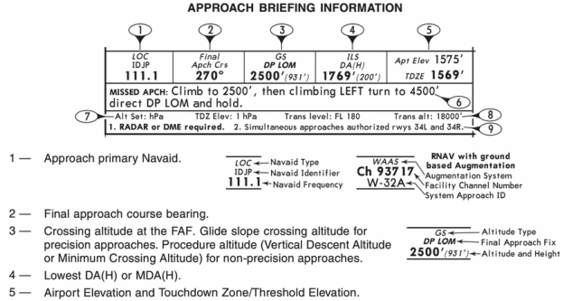
7 - Altimeter Setting information, Barometric pressure equivalents are included.
ref 2 ) Jeppesen Airway Manual
p 812.
g. During the approach to land, terrain clearance may be determined by using;
1. the QNH altimeter setting(giving altitude); or
2. under specified circumstances a QFE setting ( giving height above the QFE dataum).
ref 3 ) 대한한공 FCRM
QFE공항에서 QNH 운용 시 유의 사항
- QNH Altimeter(hPa) = reported QFE altimeter + airport elevation(hPa)
첨견 ) 특정 조건에서만 QFE(hPa)를 사용하는데, 적어도 approach나 landing 시에는 QNH 사용을 권장함.
QNH setting값을 알고있는 시점에서, 귀찮게 다시 QFE로 설정할 이유가 없다고 생각함.
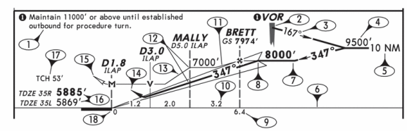
2. MOCA는 장애물에 대한 Clearance로 산악지역에서는 항공기에서 2,000ft 이외 지역에선 1,000ft를 지정하고 있다. MOCA의 VOR signal reception 반경은 몇 마일인가?

A. 22NM
B. 25NM
C. 32NM
D. 42NM
답 : A
ref ) ICM
The major difference between an MEA and MOCA is that the MOCA ensures a reliable navigation signal only within 22 NM of the facility.
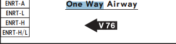
3. 항공기가 J26 Airway를 사용하고 있다면 Reporting point 에서 해야 할 행위로 가장 맞는 것은 무엇인가?

A. Compulsory reporting point 이므로 지시에 따라야 한다.
B. 라인이 Point를 돌아 가므로 그 위치를 피해서 항행 하여야 한다.
C. Report를 할 필요가 없다.
D. 정답이 없다.
답 : C
ref ) Jeppesen airway manual
COMPULSORY REPORTING POINTS — Reporting points which must be reported to ATC. They are designated on aeronautical charts by solid triangles or filed in a flight plan as fixes selected to define direct routes. These points are geographical locations which are defined by navigation aids/fixes. Pilots should discontinue position reporting over compulsory reporting points when informed by ATC that their aircraft is in “radar contact.”
첨견 ) J route를 타고있는 시점에서 이미 "radar contact"인 상황이니 보고할 필요가 없음.
A급 공역에서는 반드시 Mode C 이상이 필요함.
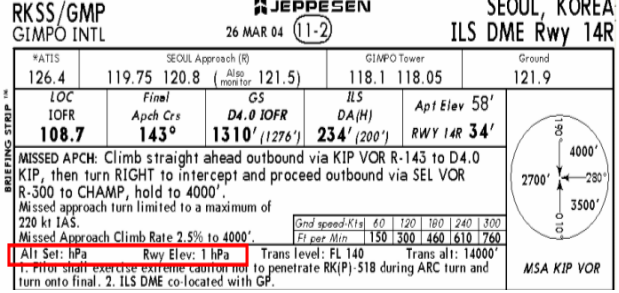
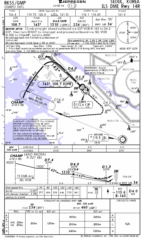
4. 김포공항 ILS-DME 14R에서 Landing시에 DA 234ft의 Full, TDZ or CL out, ALS out 중에 Full의 의미는 무엇인가?

A. All components of ILS are operating.
B. All components of the airport operating.
C. All components of the runway operating.
D. Full components of the taxiway operating.
답 : A
ref ) ICM
5. 아래 그림의 MALPA 1E로 SID절차를 수행하는데 250kts로 상승 시 1646FPM을 유지하도록 Chart에는 되어 있으나 실제로는 2000FPM으로 계속 비행하다가 3초 정도만 1400FPM으로 비행했다면?
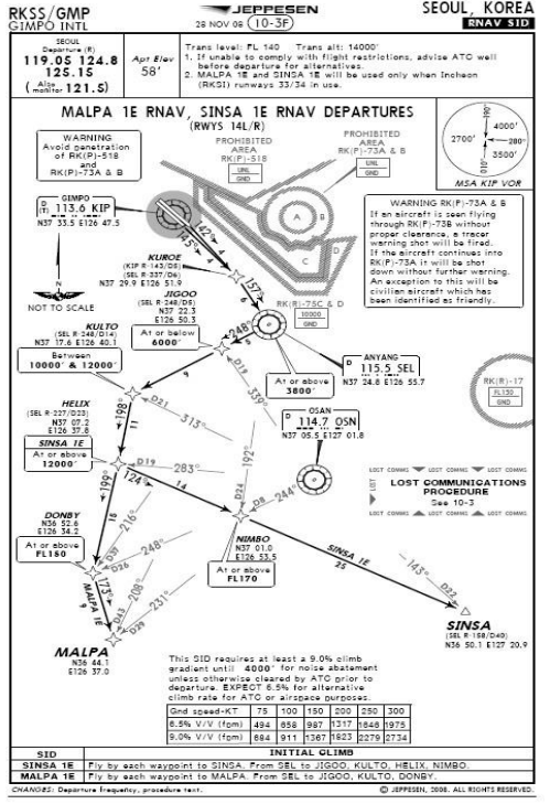
A. 항상 1646FPM이상을 유지해야 하므로 잘못된 비행이다.
B. 이륙시 평균적으로 1646FPM을 유지하면 되므로 괜찮다.
C. 3초간 1600FPM 이상으로 상승한 후 다시 1646FPM으로 가면 괜찮다.
D. SID 절차를 수행하지 못하였으므로 ATC에게 즉각적으로 보고 한다.
답 : B
ref ) ICM
... and any minimum climb gradients or restrictions associated with..
ref 2 ) Climb Gradient Requirements - SID / FAA inFO 18014(11/19/18)
(3) All airplanes must remain above this surface until reaching the stated height on the procedure. It is not a climb gradient that must be exceeded at all points during the climb.
(4) That average climb rate, at the calculated ground speed, must be maintained in compliance with parts 91 and 97, from the beginning of the climb gradient until reaching the climb gradient termination altitude.
6. 차트에 Variation이 항상 나타나 있는데, 그 이유는 무엇인가?
A. 바람의 진북을 자북으로 변환하기 위해서.
B. 진북과 자북이 차이로 공항의 Rwy 방향을 계산하기 위해서
C. 자북의 오차를 기압과 바람 그리고 온도로 계산하기 위해서
D. All of the above
답 : A
ref ) 조종사 표준교재 - 공중항법
1.4.6. 항로그리기
이것은 이 장의 앞에서 설명한 다음 식으로 구할 수 있다.
TC ± WCA = TH
TH ± Var = MH
MH ± Dev = CH
첨견 ) 말이 좀 이상하긴 한데, 억지로 넣을게 저거뿐. Heading이라는 표현이 더 맞지 않나.
7. QNH는 무엇을 뜻 하는가?
A. Height above airport elevation based on local station pressure
B. Altimeter setting 29.92 inches of mercury, 1013.2 hectopascals
C. Altitude above mean sea level based on local station pressure
D. None of the above
답 : C
ref ) Jeppesen Navigation chart
GLOSSARY
QNH - The atmospheric pressure setting which, when set in the aircraft's altimeter, will cause the altimeter to read altitudes referenced to mean sea level.
8. Enrouts상에서 MEA의 의미는?
A. 장애물, 양방향통신, 항법시설 3가지 모두 보장 받는다.
B. 장애물, 양방향통신 2가지만 보장 받는다.
C. 장애물, 합법시설 2가지만 보장 받는다.
D. 장애물만 보장 받는다.
답 : C
ref ) ICM
The minimum enroute altitude(MEA) is ordinarily the lowest published altitude between radio fixes that guarantees adequate navigation signal reception and obstruction clearance( 2,000ft in mountainous areas and 1,000 ft elsewhere). You can generally expect adequate communication at the MEA, although is is not guaranteed.
9. 김포공항 Runway 14L으로 착륙을 시도하는데 그날의 Required runway length가 11,500ft라면 착륙 가능여부는?
(단, 김포공항의 Runway 길이는 11,811ft 임)

A. 실제 착륙거리인 Glide slope length보다 길기 때문에 착륙할 수 없다.
B. ATC의 허가를 득하면 된다.
C. 이 수치만으로 판단할 수 없다.
D. 활주로보다 짧기 때문에 착륙할 수 있다.
답 : D (진짜 할 수는 있다.)
ref ) 고정익항공기를 위한 운항기술기준
8.4.5.8 착륙성능제한(Landing Limitations)
가. 비행기 : 항공운송사업자는 목적지 또는 교체비행장의 착륙접근로에서 모든 장애물을 회피하여 착륙공항의 이용가능 착륙거리 내에서 착륙이 가능하지 아니한 공항을 운항해서는 아니 되며, 목적지 또는 교체비행장 도착시의 비행기 중량이 비행기가 활주로 말단 상공 50피트 지점부터 다음 각 호에서 정한 거리 내에서 완전착륙정지 할 수 있지 않는 한 항공운송사업에 사용되는 비행기를 이륙시켜서는 아니된다.
1) 터빈엔진 비행기는 활주로 유효거리의 60퍼센트 이내
2) 왕복엔진 비행기는 활주로 유효거리의 70퍼센트 이내
ref 2) Jeppessen Navigation charts
Additional runway information band
5. When applicable, the distance from a point abeam the glide slope transmitter to the roll-out end of the RWY is shown. For PAR, the distance is from the GS interception with the RWY.
첨견 )
착륙은 할 수 있다. 하지만 이륙시킨거부터가 잘못이다.(법적으로)
사용가능한 LDA는 11,811ft이기 때문에 정말 착륙에는 문제가 없다.
문제에서 언급한 glide slop은 ref 2)에서 확인할 수 있듯 터치다운 존이 아님.
※ GIMPO International Airport (RKSS)를 SID 절차에 따라서 departing 하려 고 한다. 다음의 SID procedure chart를 참조하여 물음에 답하시오.
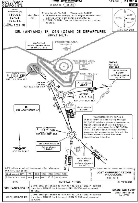
10. SID가 SEL (ANYANG)1F 일때 KIP R-143/D5 이후에 intercept 해야 할 radial은?
A. SEL R-338°
B. OSN R-350°
C. SEL R-158°
D. OSN R-338°
답 : A
ref ) chart 참고

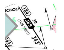
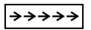
11. 다음 그림에서 항로 하단에 표시된 시간이 의미하는 것은 무엇인가?
A. 그 시간에만 양방향으로 비행할 수 있다.
B. 그 시간에만 비행할 수 없다.
C. 그 시간에만 화살표방향으로만 비행할 수 있다.
D. 그 시간에만 ATC 의 지시에 따라 비행한다.
답 : C
ref ) jeppesen navigation chart
12. 다음은 김포공항 airport chart의 일부분이다. 600’-3200m 의 의미는?
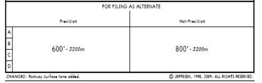
A. CEILING – VISIBILITY
B. RVR – VISIBILITY
C. VISIBILITY-CEILING
D. VISIBILITY-RVR
답 : A
ref ) jeppesen navigation chart
AIRPORT CHART LEGEND
5. Ceiling values are always shown in feet or meter as reported by the State and are shown in front of the meteorological VIS.
13. 다음 설명 중 COP에 대한 설명이 틀린 것은?
A. COP의 표시는 다음과 같다.

B. COP에는 양방향 VOR에서부터 각각의 mileage가 표시된다.
C. COP는 Midpoint 또는 Turning point에서 생략될 수 있다.
D. COP는 항시 두 VOR 중간 지점에 위치한다.
답 : D
ref ) ICM
When a change must be made somewhere other than the midpoint, a COP is established.
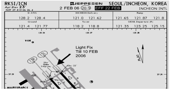
14. 다음은 인천 AIRPORT CHART다. Chart 사용 가능한 시기는 언제 인가?
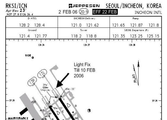
A. 발급 받은 즉시 사용 가능
B. 2006년 2월 2일
C. 2006년 2월 10일
D. 2006년 2월 22일
답 : D
ref ) jeppesen navigation chart
15. [그림 11] 보기의 안의 네모 박스 안의 기호가 의미하는 것은?
A. SID/DP and STAR Track
B. Missed approach course
C. Radar vectoring
D. Visual Flight Track
답 : D
ref ) jeppesen navigation chart

29 - Visual flight track is shown when the missed approach point is prior to the RWY threshold.
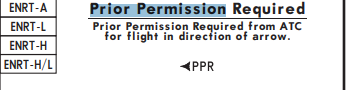
16. PPR의 의미는?
A. Prior Post Request to ATC for flight in the direction of the arrow.
B. Potential Power Resistance for any case of emergency that might happen.
C. Prior Permission Required from ATC for the flight in the direction of the arrow.
D. Professional Position Report to ATC for flight in the direction of the arrow.
답 : C
ref ) jeppesen navigation chart
17. Airway Manual의 바탕이 되는 자료로써 국가 발행 항공 정보 간행물인 이 책자는 무엇인가?
A. (FOGM) Flight Operation Guidance Manual
B. (GOAI) Government Official Aeronautical Information
C. (GOAI) Government Official Aviation Information
D. (AIP) Aeronautical Information Publication
답 : D
ref ) jeppesen navigation chart
Aeronautical Information publication
A publication issued by or with the authority of a State and containing aeronautical information of a lasting character essential to air navigation.
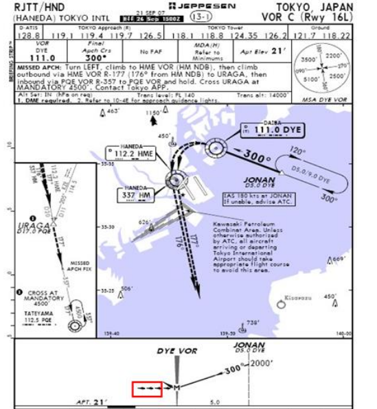
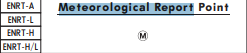
18. 다음 그림에서 ⓜ의 의미는?
A. Minimum reception Altitude
B. Mandatory Broadcast Point
C. Military Reporting Point
D. Meteorological Report Required
답 : D
ref ) jeppesen navigation chart
19. 장차 항공기에서 모니터로 Airway manual chart를 볼 수 있게 해 주는 장비는?
A. EIB(Electronic Information Bag)
B. EFB(Electronic Flight Bag).
C. EAB(Electronic Aircraft Bag)
D. EJM(Electronic Jeppeson Manual)
답 : B
ref ) ICM
The electronic flight bag exists either as a mobile device or as equipment that is installed in the aircraft. - Classes are primarily based on whether the EFB is portable and the placement of the equipment in the cockpit.
20. MCA의 Information group이 아닌 것은?
A. Victor airway name
B. The change in altitude required
C. Coordination of VOR.
D. Direction of flight
답 : C
ref ) ICM
Jeppesen usually shows an MCA next to the intersection, along with the airway number, altitude, and direction.
21. 아래 차트에서 2006년 Chart 사용 가능한 시기는 언제 인가?
A. 발급 받은 즉시 사용 가능
B. 2006년 2월 2일
C. 2006년 2월 10일
D. 2006년 2월 22일
답 : D
ref ) jeppesen navigation chart
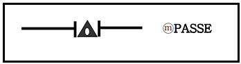
22.아래 그림이 나타내는 의미로 가장 가까운 것은 무엇인가?
A. SID/DP and STAR Track
B. One way
C. Magnetic Course
D. Visual Flight Track
답 : D
ref ) jeppesen navigation chart
29 - Visual flight track is shown when the missed approach point is prior to the RWY threshold.
23. 다음 그림에서 11800T 의 의미는?
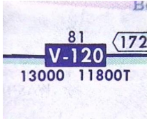
A. MEA
B. MCA
C. MOCA
D. MAA
답 : C
ref ) jeppesen navigation chart
T placed after altitude denotes a Minimum Obstruction Clearance Altitude.
24. Precision approach를 수행할 때 missed approach point (MAP)는?
A. Final approach fix
B. Minimum descent altitude
C. Decision height while on the glide slope
D. middle marker
ref ) ICM
The missed approach segment begins at the decision altitude for precision approaches and for approaches with vertical guidance.
25. 아래 그림에서 “Adequate Vis Ref”에 의미로 다음 중 틀린 것은?
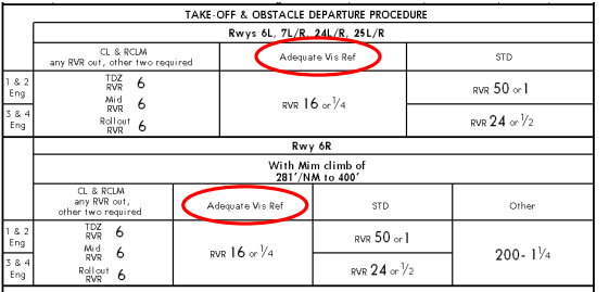
A. 작동되는 고광도 활주로등(HIRL)
B. 작동되는 활주로 접지대등(TDZ)
C. 활주로 중앙선 표식(RCLM)
D. 상기 시각보조물을 이용할 수 없는 환경에서, 다른 활주로 표식 또는 활 주로등이 이륙 활주하는 동안 지속적으로 활주로 표면 식별 및 방향을 유 지하기 위해 조종사에게 적절한 시각참조물이 제공될 때.
답 : B
ref 1 ) jeppesen navigation chart
ADEQUATE VIS REF - RWY marking or RWY lighting that provides the pilot with adequate visual reference to continuously identify the take-off surface and maintain directional control throughout the take-off run.
ref 2 ) IPH(Instrument procedure handbook)
Adequate Visual reference another set of lower-than-standard takeoff minimums is available to Part 121 and Part 135 operations as outlined in their respective OpSpecs document. When certain types of visibility reports are unavailable or specific equipment is out of service, the flight can still depart the airport if the pilot can maintain adequate visual reference. An appropriate visual aid must be available to ensure the takeoff surface can be continuously identified, and directional control can be maintained throughout the takeoff run. Appropriate visual aid include high intensity RWY lights, RWY centerline light & markings, or other RWY lighting and markings. With adequate visual references and appropriate OpSpec approaval, commercial operators may take off with a visibility of 1600 RVR or 1/4SM.
26. 김포공항의 VOR DME Rwy 32R Local altimeter setting은 1002Hpa이라면 QFE setting을 위해서 몇 Hpa로 setting 해야 하나? (Jeppesen Charts 참고)
A. 1002Hpa
B. 998Hpa
C.1004Hpa
D.1000Hpa
답 : D
ref ) 대한한공 FCRM
QFE공항에서 QNH 운용 시 유의 사항
- QNH Altimeter(hPa) = reported QFE altimeter + airport elevation(hPa)
27. 김포공항의 Takeoff Runway 기상치가 다음과 같다면 이륙 결심은? (Jeppesen Charts 참고)
TDZ RVR 350m
MID RVR 175m
R/O RVR 175m

A. 이륙 할 수 있다.
B. 이륙 할 수 없다.
C. ATC의 조건부이륙 할 수 있다.
(CHART , 김포 ILS - DME Rwy 14R)
답 : A
ref ) jeppesen navigation chart
28. TOUCHDOWN ZONE FIELD ELEVATION는 얼마인가?

A. 34FT
B. 58FT
C. 234FT
D. 460FT
답 : A
ref ) jeppesen navigation chart
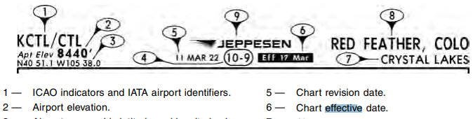
29. Chart의 Effective date은 언제인가?

A. 단지 Issue date만 알 수 있다.
B. 2004년 9월 24일
C. Issue date으로부터 2주 후.
답 : B
ref ) jeppesen navigation chart
REVISION DATE - Charts revisions are issued on Fridays. Charts are considered effective (usable) upon receipt. With regard to the coverages, charts are issued weekly or bi-weekly.

30. 비정밀접근시 FAF 와 MAP사이의 거리는?

A. 4.0
B. 1.3
C. 2.7
D. 6.1
답 : C
ref ) jeppesen navigation chart
10. Nautical Mile(NM) distance between two navaids and or fixes.
31. 다음 중 chart 내용 맞는 내용은?
A. 정밀접근시 airport elevation을 기준으로 한다.
B. 비정밀접근시 runway elevation을 기준으로 한다.
C. Clrcle-to-land은 A, B, C, D 항공기 모두 가능하다.
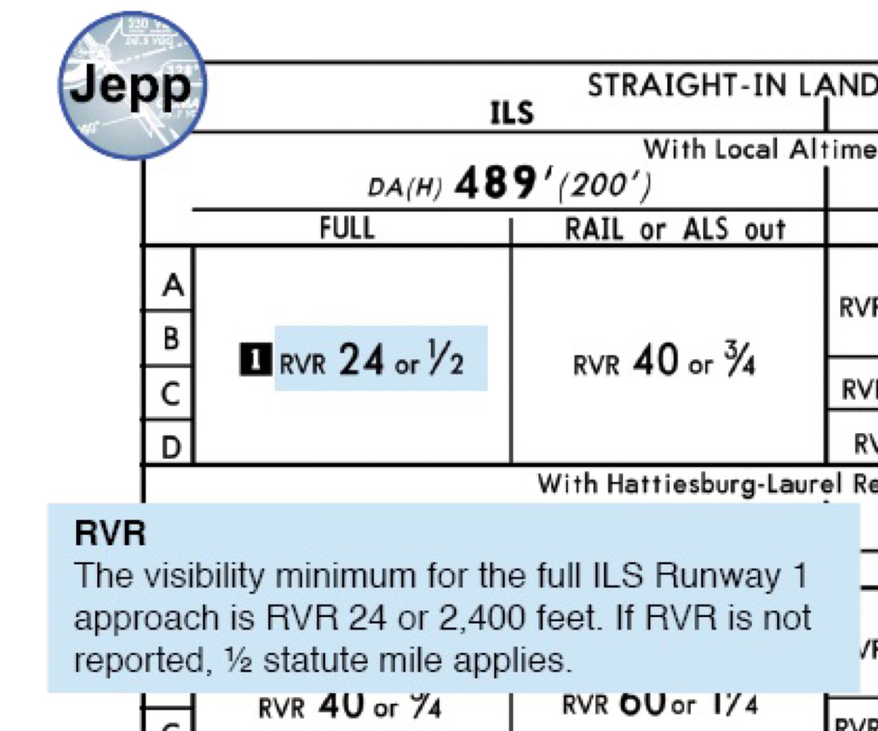
D. 시정은 RVR 값을 우선 적용한다.
답 : D
ref ) jeppesen navigation chart
DEPICTION OF EASA AIR OPS AOM IN CASE OF EXISTING STATE MINIMUMS
If State minimums are officially published, the depiction of AOM may differ from the standard depiction where all values are expressed as RVR or VIS.
a. If RVR and VIS are charted together, the RVR value is compulsory. If no RVR is reported, the reported VIS has to be used without conversion.
첨견 ) 유럽기준이라 좀 애매하긴 함.
32. Gird MORA는 몇 FT를 기준으로 표시방법이 달라지는가?
A. 13,000FT
B. 13,500FT
C. 14,000FT 10,000ft
D. 14,500FT
ref ) jeppesen navigation chart
— Grid MORA. Values 10,000 feet and greater are maroon. Values less than 10,000 feet are green. Values are depicted in hundreds of feet
33. 우리나라의 Chart Date의 사용시간 기준은?
A. 0100 Local
B. 0001 Zulu
C. 0901 Zulu
D. 1201 Local
답 : A (답지 B)
ref ) AIP, GEN 3.1 Aeronautical information services
* For the purpose of regional harmonization, 1600 UTC on the day before the AIRAC dates is used to indicate the time when the AIRAC-based information will become effective.
34. 다음 중 해당사항의 정의가 틀린 것은?
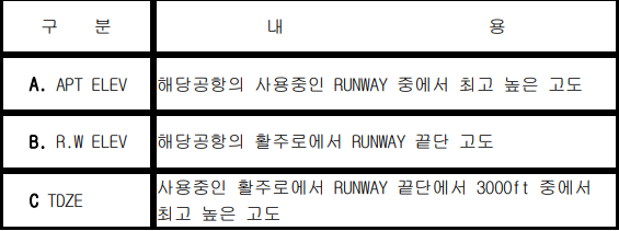
답 : B
ref ) AIM
AIRPORT ELEVATION- The highest point of an airport's usable runways measured in feet from mean sea level.
TOUCHDOWN ZONE ELEVATION- The highest elevation in the first 3,000 feet of the landing surface. TDZE is indicated on the instrument approach procedure chart when straight-in landing minimums are authorized.
RWY elevation 없음.