27. If you heard this instruction while performing a SID, altitude restrictions are canceled, according to ICAO regulations.
ATC : KE123, CLIBM TO FL 260

A. True
B. False
답 : A (답지는 B라 함.)
ref ) ICAO Doc 4444
6.3.2.4 Clearances on a SID
Clearance to aircraft on a SID with remainging published level and/or speed restrictions shall indicate if such restrictions are to be followed or are cancelled. The following phraseologies shall be used with the following meanings.
f) CLIMB UNRESTRICTED TO (level) or CLIMB TO (level) or CANCEL LEVEL AND SPEED RESTRICTIONS
ⅰ) climb to the cleared level; published level restrictions are cancelled;
ⅱ) follow the lateral profile of the SID; and
ⅱ) published speed restrictions are cancelled at the specified point(s).
28. If ATC says “DESCEND AND MAINTAIN 3000” while performing a STAR, the altitude restrictions in the STAR still remain in effect according to FAA regulations.
A. True
B. False
답 : B
ref ) AIM
5-4-1 STAR
2. If a descent clearance has been received that included a crossing restriction, pilots should expect the controller to issue an altitude to maintain. If the STAR contains published altitude and/or speed restrictions, those restrictions are canceled and pilots will receive an altitude to maintain and, if necessary, a speed.
29. What ARE correct statements (more than one) about the lights in the pictures?
(Lights are in red color)
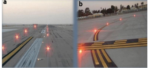
A. The picture a shows Take Off Hold Lights
B. The picture b shows Stop bar lights
C. These lights have priority over ATC instructions
D. You MUST STOP when these lights are illuminated
답 : A, C, D.
ref ) AIM
2-1-6 RWSL system
A. Introduction. RWSL is a fully automated system that provides runway status information to pilots and surface vehicle operators to clearly indicate when it is unsafe to enter, cross, takeoff from, or land on a runway. The RWSL system processes information from surveillance systems and activates Runway Entrance Lights (REL) and Takeoff Hold Lights (THL), in accordance with the position and velocity of the detected surface traffic and approach traffic. REL and THL are in-pavement light fixtures that are directly visible to pilots and surface vehicle operators. RWSL is an independent safety enhancement that does not substitute for or convey an ATC clearance. Clearance to enter, cross, takeoff from, land on, or operate on a runway must still be received from ATC. Although ATC has limited control over the system, personnel do not directly use and may not be able to view light fixture activations and deactivations during the conduct of daily ATC operations.
B. Runway Entrance Lights (REL): The REL system is composed of flush mounted, in-pavement, unidirectional light fixtures that are parallel to and focused along the taxiway centerline and directed toward the pilot at the hold line. An array of REL lights include the first light at the hold line followed by a series of evenly spaced lights to the runway edge; one additional light at the runway centerline is in line with the last two lights before the runway edge. When activated, the red lights indicate that there is high speed traffic on the runway or there is an aircraft on final approach within the activation area.
Should pilots note illuminated lights under circumstances when remaining clear of the runway is impractical for safety reasons (for example, aircraft is already on the runway), the crew should proceed according to their best judgment while understanding the illuminated lights indicate the runway is unsafe to enter or cross.
C. Takeoff Hold Lights (THL) : The THL system is composed of flush mounted, in-pavement, unidirectional light fixtures in a double longitudinal row aligned either side of the runway centerline lighting. Fixtures are focused toward the arrival end of the runway at the “line up and wait" point. THLs extend for 1,500 feet in front of the holding aircraft starting at a point 375 feet from the departure threshold. Illuminated red lights provide a signal, to an aircraft in position for takeoff or rolling, that it is unsafe to takeoff because the runway is occupied or about to be occupied by another aircraft or ground vehicle. Two aircraft, or a surface vehicle and an aircraft, are required for the lights to illuminate. The departing aircraft must be in position for takeoff or beginning takeoff roll. Another aircraft or a surface vehicle must be on or about to cross the runway.
- Never cross over illuminated red lights. Under normal circumstances, RWSL will confirm the pilot's taxi or takeoff clearance previously issued by ATC. If RWSL indicates that it is unsafe to takeoff from, land on, cross, or enter a runway, immediately notify ATC of the conflict and re-confirm the clearance.
30. What lighting system are the descriptions about?
This lighting system
- is driven automatically
- has priority over ATC instructions
- tells another aircraft is crossing / entering a runway
A. STOP BAR LIGHT
B. TAKE OFF HOLD LIGHT
C. RUNWAY ENTRANCE LIGHT
D. LAHSO LIGHT
답 : B
ref 1 ) ANNEX 14
5.3.30 Runway status lights
Runway status lights (RWSL) is a type of autonomous runway incursion warning system (ARIWS). The two basic visual components of RWSL are runway entrance lights (RELs) and take-off hold lights (THLs). Either component may be installed by itself, but the two components are designed to be complementary to each other.
ref 2 ) AIM
2-1-6 RWSL system
C. Takeoff Hold Lights (THL) : The THL system is composed of flush mounted, in-pavement, unidirectional light fixtures in a double longitudinal row aligned either side of the runway centerline lighting. Fixtures are focused toward the arrival end of the runway at the “line up and wait" point. THLs extend for 1,500 feet in front of the holding aircraft starting at a point 375 feet from the departure threshold. Illuminated red lights provide a signal, to an aircraft in position for takeoff or rolling, that it is unsafe to takeoff because the runway is occupied or about to be occupied by another aircraft or ground vehicle. Two aircraft, or a surface vehicle and an aircraft, are required for the lights to illuminate. The departing aircraft must be in position for takeoff or beginning takeoff roll. Another aircraft or a surface vehicle must be on or about to cross the runway.
31. Study the picture and choose a correct statement about it. (Lights are in red color)

A. The lights indicate the path you must follow
B. The aircraft has lined up and waiting for a takeoff clearance
C. RELs have been turned on
D. You can start taxiing once the lights have been turned off
답 : C
ref ) AIM
2-1-6 RWSL system
B. Runway Entrance Lights (REL): The REL system is composed of flush mounted, in-pavement, unidirectional light fixtures that are parallel to and focused along the taxiway centerline and directed toward the pilot at the hold line. An array of REL lights include the first light at the hold line followed by a series of evenly spaced lights to the runway edge; one additional light at the runway centerline is in line with the last two lights before the runway edge. When activated, the red lights indicate that there is high speed traffic on the runway or there is an aircraft on final approach within the activation area.
32. Choose CORRECT STATEMENTS (more than one) about flashing PAPI lights
A. It is FAROS
B. Flasing PAPI lights means the runway is occupied
C. It is advised you contact a TWR controller when the PAPI flashes
D. You can still land if a TWR controller confirm the landing clearance
답 : A, B
ref ) AIM
2-1-7 Stand-Alone Final Approach Runway Occupancy Signal(FAROS)
The FAROS system is a fully automated system that provides runway occupancy status to pilots on final approach to indicate whether it may be unsafe to land. When an aircraft or vehicle is detedcted in the RWY, the PAPI ights fixtures flash as a signal to indicate that RWY is occupied and that it may be unsafe to land.
If an aircraft or ground vehicle occupies an activation zone on the RWY, PAPI lights fixtures on that RWY will flash. The glide path indication is not affected, ex) the configuration of red and white PAPI lights observed by the pilot on approach does not change. The FAROS system flashes the PAPI lights when traffic occupies an activation zone whether or not ther is an aircraft on approach.
When a pilot observe a flashing PAPI at 500ft above AGL, the contact height, the pilot must look for and acquire the traffic on the RWY. At 300ft AGL, the pilot must concact ATC for resolution if the FAROS indication is in conflict with the clearance. IF the PAPI continues to flash, the pilot musdt execute an immediate go-around and contact ATC at the earliest possivle opportunity.
33. Which is a correct statement about ILS Critical / Sensitive area?
A. ICAO Critical & Sensitive areas are protected at all times
B. Usually ICAO sensitive & FAA critical areas are protected during IMC or LVPs in progress
C. ICAO & FAA both have established ILS critical and sensitive areas
답 : A
ref ) ICAO Annex 10 Vol 1.
2.1.9.2 ILS critical and asesitive areas. States differ in the way they choose to identify ILS protection area. Practices also iffer in how vehicle movement restrictions are managed. One method is to identify critical areas and sensitive areas as follows :
a) the ILS critical area is an area of defined dimensions about the localizer and glide path antennas where vehicles, including aircraft, are excluded during all ILS operations. The critical area is protected because the presence of
vehicles and/or aircraft inside its boundaries will cause unacceptable disturbance to the ILS signal-in-space;
b) the ILS sensitive area is an area where the parking and/or movement of vehicles, including aircraft, is controlled to
prevent the possibility of unacceptable interference to the ILS signal during ILS operations. The sensitive area is
protected against interference caused by large moving objects outside the critical area but still normally within the
airfield boundary.
Note 1.— In some States, the term “critical area” is used to describe an area that combines the critical and sensitive
areas identified in this guidance material. In cases where the critical area overlaps operational areas, specific operational
management procedures are required to ensure protection of aircraft using the ILS for intercept and final approach guidance.
--> FAA와 달리 기상 최저치의 조건이 명시되어 있지 않음.
ref 2) AIM
4-3-14 ILS
k. ILS Course Distortion
1.All pilots should be aware that disturbances to ILS localizer and glide slope courses may occur when surface vehicles or aircraft are operated near the localizer or glide slope antennas. Most ILS installations are subject to signal interference by either surface vehicles, aircraft or both. ILS CRITICAL AREAS are established near eachl ocalizer and glide slope antenna.
2. ATC issues control instructions to avoid interfering operations within ILS critical areas at controlled airports during the hours the Airport Traffic Control Tower (ATCT) is in operation asfollows:
(a) Weather Conditions. Less than ceiling 800 feet and/or visibility 2 miles.
---> sensitive area에 대한 언급이 없음
34. There are 2 RWY holding position markings defined by ICAO, called pattern A and pattern B, which are better known as RWY HOLD SHORT LINE and ILS CRITICAL HOLD LINE.
A. True
B. False
답 : A
ref 1 ) Annex 14 vol 1.

ref 2 ) ICAO standard PPT from FAA
Holding position marking 내용 참고.
35. Which of the following is correct about RWY holding position?
A. An authorization from ATC is needed to proceed beyond it
B. It includes ILS/MLS critical/sensitive area
C. “Holding Point” is used to designate rwy holding position in radiotelephony
D. All
답 : D
ref ) Annex 14
Runway-holding position.
A designated position intended to protect a runway, an obstacle limitation surface, or an ILS/ MLS critical/sensitive area at which taxiing aircraft and vehicles shall stop and hold, unless otherwise authorized by the aerodrome control tower.
Note.— In radiotelephony phraseologies, the expression “holding point” is used to designate the runway-holding position.
36. ATIS에 대한 설명 중 틀린 것은?
A. ATIS (Automatic Terminal Information Service)는 교통량이 많은 공항 에서, 녹음된 공항 관련 각종 필수 정보를 연속적으로 방송하는 서비스이 다.
B. ATIS의 목적은 필수적이고 반복적인 공항과 날씨 관련 정보의 제공을 자동화 함으로써 관제사의 효율성을 높이고 주파수 혼잡을 덜어주기 위함 에 있다.
C. ATIS 정보는 정보 식별자, 정보가 발표된 표준시, 운고, 시정, 온도, 이슬, 바람의 방향과 세기, 고도계 정보, 사용 활주로 정보 등을 제공한다.
D. VHF 주파수를 통해 전송되는 ATIS는 전송 기지로부터 100 nm까지 그 리고 최대 고도 30,000 feet까지 수신될 수 있다.
답 : D
ref ) AIM
4-1-13 ATIS( Automated Terminal Information Service)
a. ATIS is the continuous broadcast of recorded noncontrol information in selected high activity terminal areas. Its purpose is to improve controller effectiveness and to relieve frequency congestion by automating the repetitive transmission of essential but routine information. The information is continuously broadcast over a discrete VHF radio frequency or the voice portion of a local NAVAID. Arrival ATIS transmissions on a discrete VHF radio frequency are engineered according to the individual facilityrequirements, which would normally be a protected service volume of 20 NM to 60 NM from the ATIS site and a maximum altitude of 25,000 feet AGL. In the case of a departure ATIS, the protected service volume cannot exceed 5 NM and 100 feet AGL. At most locations, ATIS signals may be received on the surface of the airport, but local conditions may limit the maximum ATIS reception distance and/or altitude.
37. 활주로에 착륙 후 속도를 줄이고 있다. 남은 활주로의 길이가 3,000 feet 지점부터 Runway Centerline Light와 Runway Edge Light의 색에 대한 설명으 로 틀린 것은?
A. Runway Centerline Lights는 정밀 접근이 실시되는 일부 활주로에 악기상 상황에서 이루어지는 착륙을 원활히 하고자 하는 목적으로 50 feet 간 격으로 설치되어있다.
B. 활주로가 3,000 feet 남은 지점부터 RCL는 White와 Red가 교대로 나타 나다가, 마지막 1,000 feet를 남겨놓고 Red로 다 바뀐다.
C. Runway Edge Lights는 활주로의 길이가 2,000 feet 남은 지점부터 White 에서 amber로 바뀐다.
D. Runway Edge Lights의 마지막 1,000 feet 는 Red 색이다.
답 : D
ref ) AIM
2-1-4 Runway edge lights system
a. Runway edge lights are used to outline the edges of runways during periods of darkness or restricted visibility conditions. These light systems are classified according to the intensity or brightness they are capable of producing: they are the High Intensity Runway Lights (HIRL), Medium Intensity Runway Lights (MIRL), and the Low Intensity Runway Lights (LIRL). The HIRL and MIRLsystems have variable intensity controls, whereas the LIRLs normally have one intensity setting.
b. The runway edge lights are white, except on instrument runways yellow replaces white on the last 2,000 feet or half the runway length, whichever is less, to form a caution zone for landings.
c. The lights marking the ends of the runway emit red light toward the runway to indicate the end of runway to a departing aircraft and emit green outward from the runway end to indicate the threshold tolanding aircraft.
2-1-5 Runway Centerline Lights System
a. Runway Centerline Lighting System (RCLS). Runway centerline lights are installed on some precision approach runways to facilitate landing under adverse visibility conditions. They are located along the runway centerline and are spaced at 50−foot intervals. When viewed from the landing threshold, the runway centerline lights are white until the last 3,000 feet of the runway. The white lights begin to alternate with red for the next 2,000 feet, and for the last 1,000 feet of the runway, all centerline lights are red.
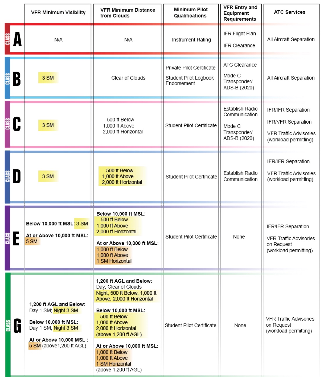
38. Class D 공역에 대한 설명으로 틀린 것은?
A. Class D 공역 높이는 지표면에서 대략 2500 feet AGL까지 되고, 반지름이 4NM 정도 되는 원통형의 공역이다.
B. Class D 공역 안에 위치한 공항의 관제탑이 24시간 운영이 아닌 경우, 해당 공역 관제탑이 운영되는 동안에만 Class D 공역이 된다.
C. 조종사는 Class D 공역에 진입 하기 전 관제탑과 쌍방향 무선 통신 (Two way radio communication) 을 확립해야 한다. D. Class D 공역 안에서 비행하는 동안 조종사는 최소 3 SM 시정을 확보하고, 구름으로부터 clear of clouds를 유지해야 한다.
답 : D
ref 1) AIM
3-2-5 Class D airspace
a. Definition. Generally, Class D airspace extends upward from the surface to 2,500 feet above the airport elevation (charted in MSL) surrounding those airports that have an operational control tower. The configuration of each Class D airspace area is individually tailored and when instrument procedures are published, the airspace will normally be designed to contain the procedures.
1. Class D surface areas may be designated as full-time (24 hour tower operations) or part-time. Part-time Class D effective times are published in the Chart Supplement U.S.
2. Where a Class D surface area is part-time, the airspace may revert to either a Class E surface area (see paragraph 3−2−6e1) or Class G airspace. When a part–time Class D surface area changes to Class G, the surface area becomes Class G airspace up to, but not including, the overlying controlled airspace.
b. Operating Rules and Pilot/Equipment Requirements:
1. Pilot Certification. No specific certification required.
2. Equipment. Unless otherwise authorized by ATC, an operable two−way radio is required.
3. Arrival or Through Flight Entry Requirements. Two−way radio communication
must be established with the ATC facility providing ATC services prior to entry and thereafter maintain those communications while in the Class D airspace.
Pilots of arriving aircraft should contact the control tower on the publicized frequency and give their position, altitude, destination, and any request(s).
Radio contact should be initiated far enough from the Class D airspace boundary to preclude entering the Class D airspace before two−way radio communications are established.
ref 2) PPM
CLASS D AIRSPACE
An airport that has an operating control tower, but does not provide Class B or C airspace ATC services, is surrounded by Class D airspace. The control TWR provides sequencing and traffic advisories to VFR aircraft operating into and out of the airport, and IFR traffic separation. You must establish two-way radio communication with the TWR prior to entering Class D airspace and maintain radio contact during all operations to, from, or on that airport. As a general rule, you should avoid Class D airspace except to take off or land at an airport within the area.
The airspace at an airport with a part-time control TWR is designated as Class D only when the TWR is in operation. At airports where the TWR operates part time, the airspace changes to Class E, or a combination of Class E and Class G when the TWR is closed. For these airports, check the Airport/Facility Directory in the Chart Supplement for the TWR's hours of operation and the airspace designation.
Class D airspace can be various sizes and shapes, depending on the insrument approach procedures established for that airport. Most Class D is a circle with a radius of appproximately 4NM extending up to 2,500ft AGL.
첨견 ) AIP ENR 1.4 - 6
2.4 D 등급 관제공역
가. 정의 : 인천비행정보구역 중 다음과 같이 곡토부장관이 공고한 공역
(1) 청주공항을 제외한 공항의 공역 크기는 관제탑이 운영되는 공항반경 5NM 이내, 지표면으로부터 공항표고 5,000ft 이하의 각 공항별로 설정된 관제권 상한고도까지의 공역으로 설정된 공항은 다음과 같다.
(2) 최저항로고도(MEA) 이상 평균해면 20,000ft 이하의 모든 항공로
(3) 서울접근관제구역 중 B등급 이외의 관제공역으로서 평균해면 10,000ft 초과, 평균하면 18,500ft 이하의 공역
다. 무선설비 : D등급 공역을 비행하고자 하는 항공기는 관할 항공교통관제기관의 허가가 없는 한 송수신무선통신기 및 자동고도 보고장치를 갖춘 트랜스폰더를 구비해야한다. 다만 자동고도보고장치를 갖춘 트랜스폰더를 구비할 수 없는 군용기에 대해서는 동조 적용을 잠정 유보한다.
바. 비행절차
(1) D등급 공역 내로 들어가는 모든 항공기는 진입전에 관할 ATC 기관과 무선교신이 이루어져야 하고 항공기 위치, 고도, 레이다 비컨코드, 목적지를 알리고 D등급 업무를 요청하여 허가를 받아야 하며 D등급 공역 내에서 비행하는 동안에는 계속 무선교신을 유지하여야 한다. 다만 한국군 소속 VFR 항공기가 서울접근관제구역 내 D등급 공역을 통과하거나 항공로의 D등급 공역을 횡단할 때에는, D등급 공역 절차를 준수하는 대신 관계기관간 합의서에 명시된 비행정보 통보절차에 의한다.
(2) D등급 공역으로 설정된 공항에서 이륙하는 항공기는 관할 ATC 기관과 D등급 공역을 벗어날 때까지 무선교신을 유지하여야 한다.
(3) 관할 ATC 기관의 허가가 없는 한 D등급 공역 중 항공로비행은 계기비행방식에 의한다.
(4) D등급 공역 내에서 비행하는 모든 항공기는 평균해면 10 000 피트 미만의 고도에서는 지시대기속도 250 노트 이하로 비행하여야 하며, 공항반경 4NM 내의 지표면으로부터 2 500 피트 이하의 고도에서는 지시대기속도 200 노트 이하로 비행하여야 한다. 다만 항공기 성능상 이에 따를 수 없는 경우, 관할 ATC 기관의 허가를 얻어 비행할 경우에는 그러하지 아니하다.
39. Class C 공역에 대한 설명으로 틀린 것은?
A. Core Area, 안쪽 공역은 반지름 약 5 NM에 높이는 약 4,000 feet AGL 이 다. Shelf Area, 바깥 공역은 반지름 약 10 NM에 높이는 1,200 feet AGL 부터 4,000 feet AGL 이다. 대부분의 Class C 공역은 이와 같은 모양을 하 고 있지만 약간의 차이는 있다.
B. 조종사는 Class C 공역에 진입 하기 전 그 지역을 관할하는 해당 ATC와 쌍방향 무선 통신 (Two way radio communication) 을 확립해야 하나, Mode C Transponder는 요구되지 않는다.
C. ATC는 IFR 항공기와 IFR 또는 IFR 항공기와 VFR 항공기간에 분리 서비 를 제공하고, 업무가 과중하지 않을 경우 VFR 항공기에게 Traffic Advisory를 제공한다.
D. Class C 공역에서 비행하는 동안 조종사는 최소 3 SM 시정을 확보하고, 구 름으로부터 아래로 500 feet, 위로 1000 feet, 옆으로 2000 feet 거리를 유 지해야 한다.
답 : B
ref 1 ) AIM
3−2−4. Class C Airspacea.
Definition. Generally, that airspace from the surface to 4,000 feet above the airport elevation(charted in MSL) surrounding those airports that have an operational control tower, are serviced by a radar approach control, and that have a certain number of IFR operations or passenger enplanements. Although the configuration of each Class C airspace area is individually tailored, the airspace usually consists of a 5 NM radius core surface area that extends from the surface up to 4,000 feet above the airport elevation, and a 10 NM radius shelf area that extends no lowerthan 1,200 feet up to 4,000 feet above the airport elevation.
b. Charts. Class C airspace is charted on Sectional Charts, IFR En Route Low Altitude, and Terminal Area Charts where appropriate.
c. Operating Rules and Pilot/Equipment Requirements:
1. Pilot Certification. No specific certification required.
2. Equipment.
(a)Two-way radio; and (b)Unless otherwise authorized by ATC, an operable radar beacon transponder with automatic altitude reporting equipment. -> MODE C
3. Arrival or Through Flight Entry Requirements. Two-way radio communication must be established with the ATC facility providing ATC services prior to entry and thereafter maintain those communications while in Class C airspace. Pilots of
arriving aircraft should contact the Class C airspace ATC facility on the publicized frequency and give their position, altitude, radar beacon code, destination, and request Class C service. Radio contact should be initiated far enough from the Class Cairspace boundary to preclude entering Class Cairspace before two-way radio communications are established.
NOTE−1. If the controller responds to a radio call with, “(aircraft callsign) standby,” radio communications have been established and the pilot can enter the Class C airspace.
d. Air Traffic Services.
When two-way radio communications and radar contact are established, all participating VFR aircraft are:
1. Sequenced to the primary airport.
2. Provided Class C services within the Class C airspace and the outer area.
3. Provided basic radar services(A radar service for VFR aircraft which includes safety alerts, traffic advisories, and limited radar vectoring, as well as aircraft sequencing at some terminal locations.) beyond the outer area on a workload permitting basis. This can be terminated by the controller if workload dictates.
e. Aircraft Separation.
Separation is provided within the Class C airspace and the outer area after two-way radio communications and radar contact are established. VFR aircraft are separated from IFR aircraft within the Class C airspace by any of the following:
1. Visual separation.
2. 500 feet vertical; except when operating beneath a heavy jet.
3. Target resolution.
ref 2 ) PPM
첨견 ) AIP ENR 1.4 - 6
2.3 C 등급 관제공역
가. 정의
인천 비행정보구역 중 계기비행 운항이나 승객 수송이 많은 공항으로 관제탑이 운용되고 레이더 접근관제업무가 제공되는 공항주변의 공역으로서 국토교통부장관이 공고한 공역이다.
나. 비행요건
계기비행(IFR)․시계비행(VFR) 운항이 모두 가능하며, 조종사에게 특별한 자격이 요구되지는 않는다.
다. 무선설비
C등급 공역을 비행하고자 하는 항공기는 관할 항공교통관제(ATC) 기관의 허가가 없는 한 송수신무선통신기 및 자동고도보고장치를 갖춘 트랜스폰더를 구비해야한다. 다만 자동고도보고장치를 갖춘 트랜스폰더를 구비할 수 없는 군용기에 대해서는 동조 적용을 잠정 유보한다.
라. 항공기 분리
(1) C등급 공역 내에서 비행하는 항공기간 분리는 무선교신과 레이다식별이 이루어진 후에 제공된다.
(2) IFR 항공기는 VFR 및 다른 IFR 항공기로부터 분리업무가 제공되며, VFR 항공기는 IFR 항공기로부터의 분리업무를 제공받는다. 그러나 VFR 헬기를 IFR 헬기로부터 분리시킬 필요는 없다.
마. 제공 업무
(1) IFR 항공기에게 ATC 업무가 제공되며, VFR 항공기에게는 IFR 항공기로부터 분리를 위한 ATC 업무가 제공된다.
(2) C등급 공역으로 설정된 공항에 착륙하는 모든 항공기에 대하여 순서를 배정하여 준다.
(3) VFR 항공기간에 교통정보가 제공되며, VFR 항공기가 요청 시 업무량이 허락된다면 교통회피 조언을 제공해줄 수 있다.
(4) 조종사가 C등급 공역에서의 업무의 종료를 요구하지 않는 한, 그 항공기가 C등급 공역을 떠날 때까지 제공업무가 지속되어야 한다.
바. 비행절차
(1) C등급 공역 내로 들어가는 모든 항공기 조종사는 진입 전에 관할 ATC 기관과 무선교신이 이루어져야 하고 항공기 위치, 고도, 레이다 비컨코드, 목적지를 알리고 C등급 업무를 요청하여 허가를 받아야 하며 C등급 공역 내에서 비행하는 동안에는 계속 무선교신을 유지하여야 한다.
(2) C등급 공역으로 설정된 공항에서 이륙하는 항공기 조종사는 관할 ATC기관과 무선교신을 하여야 하며 C등급 공역을 벗어날 때까지 무선교신을 유지하여야 한다.
(3) C등급 공역 내에서 비행하는 모든 항공기는 평균해면 10,000 피트 미만의 고도에서는 지시대기속도 250노트 이하로 비행하여야 하며, 공항반경 4NM 내의 지표면으로부터 2,500 피트 이하의 고도에서는 지시대기속도 200노트 이하로 비행하여야 한다. 다만 항공기 성능상 이에 따를 수 없는 경우, 관할 ATC 기관의 허가를 얻어 비행할 경우에는 그러하지 아니하다.
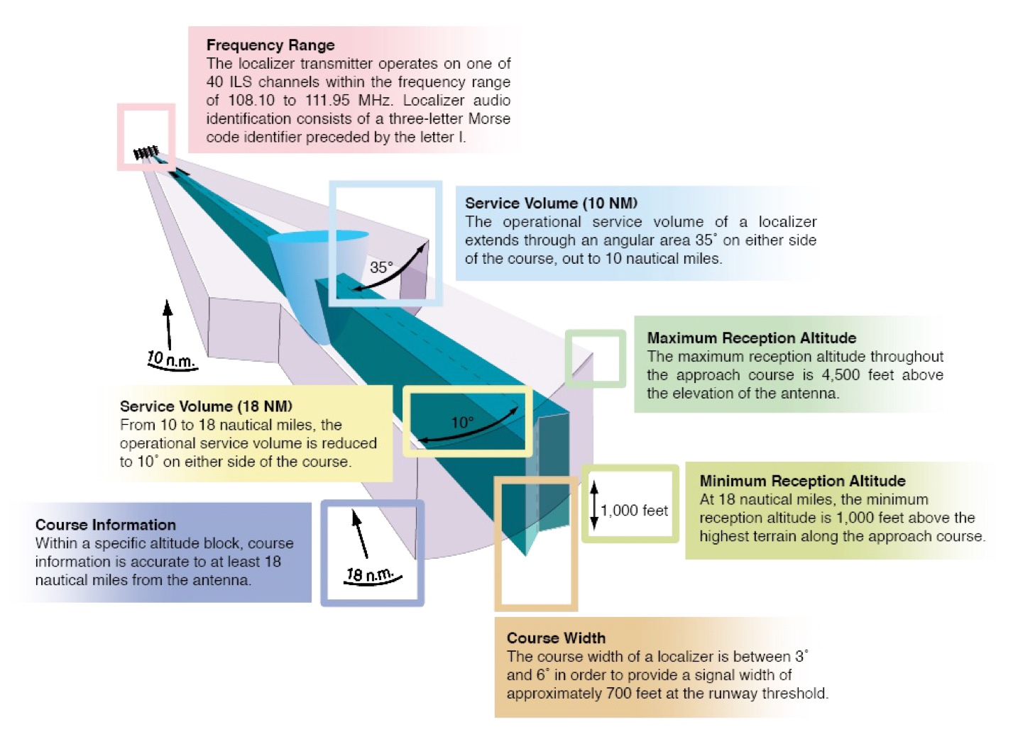
40. Localizer Coverage 에 대한 설명으로 옳은 것은?
A. Localizer 안테나로부터 18 NM 까지는 Localizer course 양쪽으로 각각 10 도 범위.
B. Localizer 안테나로부터 10 NM 까지는 Localizer course 양쪽으로 각각 18 도 범위.
C. Localizer 안테나로부터 18 NM 까지는 Localizer course 양쪽으로 각각 5 도 범위.
D. Localizer 안테나로부터 10 NM 까지는 Localizer course 양쪽으로 각각 30 도 범위.
답 : A
ref ) 조종사 표준교재 - 비행이론
로컬라이저(Localizer)
주파수 범위 내에서 송신되며, 신호를 통하여 안테나 위치에서 18NM 떨어진 곳의 4,500ft 지점으로부터 강하 경로를 거쳐 활주로 말단까지 접근 방위각 정보를 제공한다.
범위 18NM 까지 각 10도, 10NM까지 각 35도.

ref 2 ) ICM
41. Wake Turbulence에 대한 설명으로 틀린 것은?
A. 항공기가 양력을 발생하면, 날개 아래에서는 High Pressure가 발생되고 위 에서는 Low Pressure 가 발생된다. 이 기압차이는 Wing Tip부분에서 날개 아래에서 위로 올라와 회전하는 후류를 만들게 된다. 이 후류를 Vortex라 고 한다.
B. 바람이 없는 상황에서 Vortex는 활주로 위에서 양쪽으로 약 3 knots 정도 의 속도로 좌우로 퍼져나간다.
C. Vortex는 항공기가 Heavy, Slow, Landing Configuration 일 때 가장 큰 위 력을 발휘한다.
D. 특히 Light quartering tailwind (약 45도 배풍) 일 때 Wingtip vortex가 활 주로 위에 머물게 되므로 가장 심한 Wake Turbulence가 발생한다.
답 : C
ref ) ATP
17.4 WINGTIP VORTICES/WAKE TURBULENCE
1. Wingtip vortices (wake turbulence) are created when airplanes develop lift.
a. The vortex characteristics may be altered by extending the flaps or changing the speed.
2. The greatest wingtip vortex strength occurs behind heavy, clean (flaps and gear up), and slow aircraft.
a. The takeoff of a jet transport airplane, when it has a high gross weight and a high angle of attack, is an example of this.
3. Vortices circulate outward, upward, and around the wingtip (from the higher pressure below to the lower pressure above).
4. Wingtip vortices created by larger (transport category) aircraft tend to sink into the flight path of airplanes operating below the generating airplane.
5. A light crosswind can result in an upwind vortex remaining in the touchdown zone for a longer period of time.
6. Light quartering tailwinds hold the vortices of preceding aircraft on the runway for the longest period of time.
7. When taking off behind a departing jet, climb above and stay upwind of the jet aircraft’s flight path until you are able to turn clear of the wake.
8. When taking off behind a jet that has just landed, plan to lift off beyond the point where the jet touched down.
42. “Hold northeast of 10 DME fix on 030º radial of KIP VOR, 5 miles leg.” (항공기는 100 radial 선상에서 10 miles위치) Entry Type, Inbound Course, Outbound Heading, Entry Type을 설명하시오.
A. Inbound course 210, outbound heading 030, Entry Type은 Parallel.
B. Inbound course 210, outbound heading 030, Entry Type은 Tear Drop.
C. Inbound course 030, outbound heading 210, Entry Type은 Tear Drop.
D. Inbound course 030, outbound heading 210, Entry Type은 Parallel.
답 : B
43. Federal Airway (Victor Airway)에 대한 설명으로 틀린 것은?
A. 지상 항행 설비들을 연결해 놓은 Airway를 Federal Airways 또는 Victor Airways라고 하며, VFR 차트에는 파란색 선으로 표시된다.
B. Federal Airway는 Class E airspace 에 포함된다.
C. 높이는 1,200 feet AGL부터 시작해서 18,000 MSL 미만 까지 이다.
D. 폭은 중앙선에서 양쪽으로 각각 5 nm 이다.
답 : D
ref 1 ) ICM
Class E airspace
Another segment of Class E airspace is the low altitude airway system connecting one navaid to another. These routes are used by VFR as well as IFR aircraft, and are called Federal airways, or Victor airways. These airways are based on VOR or VORTAC navigation aids and are identified by a V and the airway number. Airways are usually 8NM wide, begine at 1,200ft AGL, and extend up to, but not including 18,000ft MSL.
44. Special VFR에 대한 설명으로 틀린 것은?
A. VFR chart상에 “NO SVFR” 이라고 적혀있으면, 이는 해당 공항에서는 special VFR 허가를 얻을 수 없음을 나타내는 것이다.
B. 기상이 VFR weather Minima 이하인 경우에도 VFR 비행을 하고자 할 경 우, 조종사는 ATC로부터 Special VFR 허가를 얻으면 Class B, C, D, E 공 역에서 비행을 할 수 있다.
C. 비록 Special VFR 허가를 얻었다 하더라도 조종사는 최소 1 statute mile의 Ground visibility를 확보하고, Clear of Clouds를 유지해야 한다.
D. 계기비행 자격이 없다면 일몰 1시간 전부터 일출 1시간 후까지 Special VFR 허가를 얻을 수 없다.
답 : D
ref ) ICM
SPECIAL VFR
In addition to maintaining the VFR minimums specified in Figure 3-14, you may only operate within the areas of Class B, C, D, or E airspace that extend to the surface around an airport, when the ground visibility is at least 3 statute miles and the cloud ceiling is at least 1,000 feet AGL. If ground visibility is not reported, you can use flight visibility. When the weather is below these VFR minimums, and there is no conflicting IFR traffic, a special VFR clearance may be obtained from the ATC facility having jurisdiction over the affected airspace. A special VFR clearance can allow you to enter, leave, or operate within most Class D and Class E surface areas and some Class B and Class C surface areas if the flight visibility is at least 1 statute mile and you can remain clear of clouds. At least one statute mile ground visibility is required for takeoff and landing; however, if ground visibility is not reported, you must have at least 1 statute mile flight visibility.
Special VFR clearances require you to maintain a minimum ground visibility (or flight visibility, if ground visibility is not reported) of one mile and remain clear of clouds.
Special VFR is not permitted between sunset and sunrise unless you have a current instrument rating and the aircraft is equipped for instrument flight. In addition, special VFR clearances are not issued to fixed-wing aircraft (day or night) at the airports that are listed in Section 3 of Appendix D of FAR 91.
To operate an airplane under special VFR at night within Class D airspace, you must hold an instrument rating and the airplane must be equipped for instrument flight.
45. 일반적인 속도 규정에 대한 설명으로 틀린 것은?
A. 일반적으로 10,000 feet 미만에서 최대 속도는 250 knots이다.
B. Class D와 C 공역내의 반지름 4NM, 높이는 2,500 feet AGL 공역에서의 최대 속도는 200 knots 이다.
C. Class B 공역내의 VFR Corridor의 최대 속도는 250 knots 이다.
D. 만약 항공기의 Minimum Safe Airspeed (최저 안전 속도)가 해당 공역의 최대 속도 보다 클 경우 조종사는 Minimum Safe Airspeed로 비행할 수 있다.
답 : C (답지 B 어림도 없지)
ref )AIP ENR 1.4 - 6
B등급 공역내에서 비행하는 모든 항공기는 평균해면 10,000ft 미만의 고도에서는 지시대기속도 250kt 이하로 비행하여야 한다.
C등급 공역 내에서 비행하는 모든 항공기는 평균해면 10,000 피트 미만의 고도에서는 지시대기속도 250 노트 이하로 비행하여야 하며, 공항반경 4NM 내의 지표면으로부터 2,500 피트 이하의 고도에서는 지시대기속도 200노트 이하로 비행하여야 한다.
D등급 공역 내에서 비행하는 모든 항공기는 평균해면 10,000 피트 미만의 고도에서는 지시대기속도 250 노트 이하로 비행하여야 하며, 공항반경 4NM 내의 지표면으로부터 2,500 피트 이하의 고도에서는 지시대기속도 200 노트 이하로 비행하여야 한다. 다만 항공기 성능상 이에 따를 수 없는 경우, 관할 ATC 기관의 허가를 얻어 비행할 경우 에는 그러하지 아니하다.
E등급 공역 내에서 ATC 기관과 무선교신을 유지하면서 비행하는 모든 항공기는 관할 ATC 기관의 허가가 없는 한, 평균해면 10,000 피트 미만의 고도에서는 지시대기속도(IAS) 250 노트 이하로 비행하여야 한다.
ref 2) ICM
Aircraft Speed Limits
You generally may not operate an aircraft below 10,000ft MSL at a speed greater than 250kts KIAS. Further, unless otherwise authorised or required by ATC, you may not operate an aircraft at or below 2,500ft above the surface within 4NM of the primary airport of Class C or Class D airspace area at a speed greater than 200KIAS. The 200 KIAS limit also applies to the airspace underlying a class B airspace area or in a VFR corridor designated through such airspace.
46. 만약 출발하는 공항에서 Altimeter Setting 값을 얻을 수 없는 경우, 어떠한 Altimeter를 Setting해야 하는가?
A. Zero
B. 29.92 in. Hg.
C. 출발 공항 고도
D. 도착 공항 고도
답 : C
ref ) AIM
3.3.1.1.
If the aircraft is not equipped with a radio, set the altimeter to the elevation of the departure airport or use an available appropriate altimeter setting prior to departure.
47. IFR 비행도중 Emergency 상황이 발생하여 ATC의 지시를 지킬 수 없는 상황에 처했다. 규정에 의하면, 어떠한 행동을 반드시 취해야 하는가?
A. Squawk 7600.
B. Deviation을 가능한 빨리 ATC에 보고한다.
C. 수정된 지시를 요구하거나 IFR 비행 계획을 취소한다.
D. Deviation에 대한 자세한 보고서를 비행 후 48시간 이내에 해당 ATC 장에 게 제출한다.
답 : B
ref ) 항공안전법 시행규칙
제184조(비행계획의 준수) ① 법 제67조에 따라 항공기는 비행 시 제출된 비행계획을 지켜야 한다. 다만, 비행계획의 변경에 대하여 항공교통관제기관의 허가를 받은 경우 또는 긴급한 조치가 필요한 비상상황이 발생한 경우에는 그러하지 아니하다. 이 경우 비상상황의 발생으로 비행계획을 지키지 못하였을 때에는 긴급 조치를 한 즉시 이를 관할 항공교통관제기관에 통보하여야 한다.
② 항공기는 항공로의 중심선을 따라 비행하여야 하며, 항공로가 설정되지 아니한 지역에서는 항행안전시설과 그 비행로의 정해진 지점 간을 직선으로 비행하여야 한다. 다만, 국토교통부장관이 별도로 정한 바에 따르거나 관할 항공교통관제기관으로부터 달리 지시를 받은 경우에는 그러하지 아니하다.
③ 항공기는 제2항을 지킬 수 없는 경우 관할 항공교통업무기관에 통보하여야 한다.
48. IFR 비행을 하는 항공기의 PIC는 Controlled Airspace에서 다음 사항을 보고해야 한다.
A. VFR Condition으로 진입
B. 새 Airway로 Heading 변경.
C. 예상치 못한 기상에 조우했을 때
D. Radar Control 하에서 Designated Checkpoints를 통과할 때
답 : C
ref ) AIM
5-3-3 Additional reports(요약)
b. 조종사는 예보되자 않은 기상상태에 조우하거나 또는 예보된 위험한 기상상태에 조우할 때 항공교통 관제기관에다 그런 기상상태를 보고하여야 한다.
49. IFR 비행을 위해 필요한 최소 항법 장비는?
A. VOR 수신기, Transponder, DME
B. ILS, VOR 수신기
C. IFR 비행을 위해 사용되는 시설에 적합한 항법 장비
D. VOR, ADF 수신기, Mode C Transponder.
답 : C
첨견 ) 필수 계기는 법적으로 명시되어 있으나 항법 장비는 그러하지 않음. 당연히 각 필요한 장비가 있어야겠지.
50. 항공기 Position Light는 언제부터 언제까지 사용해야 (illuminated) 하는 가?
A. 일출부터 일몰까지
B. 일몰부터 일출까지
C. 일몰 1시간 후부터 일출 1시간 후까지
D. 일몰 1시간 전부터 일출 1시간 후까지
답 : B
ref ) 고정익항공기를 위한 운항기술기준
8.1.11.12 항공기 등불의 사용
가. 항공기에 적색 충돌 방지등이 장치되었을 경우 기장은 엔진 시동 전에 스위치를 켜야 하며 엔진이 작동되고 있는 동안에는 항상 등을 켜고 있어야 한다.
나. 기장은 다음 각 호와 같은 항공기 등불을 켜지 않으면 일몰과 일출사이의 시간동안 항공기를 운항하여서는 아니 된다.
1) 항행등
2) 공중충돌방지등(장착되어 있을 경우)
주. 섬광등이 임무를 수행하는데 나쁜 영향을 미치거나 외부에 있는 사람에게 눈부심을 주어 위험을 유발할 수 있는 경우 조종사는 섬광등을 끄거나 빛의 강도를 줄일 수 있다.
51. 어느 고도 이상에서 VFR Cruising 고도를 사용해야 하는가?
A. At more than 3,000 feet MSL based on true course.
B. At more than 3,000 feet MSL based on true heading.
C. At more than 3,000 feet AGL based on magnetic course.
D. At more than 3,000 feet AGL based on magnetic heading.
답 : C
ref ) AIM
TBL 3-1-2 VFR cruising altitudes and Flight levels
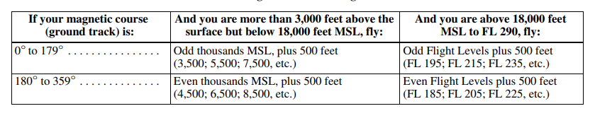
기준은 Magnetic Course, more than 3000ft above
52. ELT의 Rechargeable Battery는 몇 % 가 사용되기 전에 재충전되어야 하 는가?
A. 40%
B. 50%
C. 60%
D. 70%
답 : B
ref ) 고정익항공기를 위한 운항기술기준
7.1.14.4 비상위치지시용 무선표지설비(Emergency Locator Transmitter)
가.모든 항공기는 항공안전법 시행규칙 제107조에 따라 비상위치지시용 무선표지설비(ELT)를 장착하여야 한다.
나.비상위치지시용 무선표지설비에 사용되는 건전지는 다음의 경우 교체하여야 한다. 다만, 충전이 가능한 경우에는 재충전한다.
1) 1시간 이상 연속 송신기를 사용한 경우 또는
2) 유효수명의 50퍼센트(충전용 건전지의 경우 충전유효수명의 50 퍼센트)가 지난 경우
3)교체 또는 충전할 수 있는 비상위치지시용 무선표지설비 건전지의 유효일자는 송신기의 외부에 읽기 쉽게 표시하여야 한다.
53. Mode C 능력을 갖춘 사용가능 한 Transponder는 2,500 feet AGL 이하 공역을 제외한 모든 공역의 어느 고도 이상에서 필요한가?
A. 10,000 feet MSL
B. 12,500 feet AGL
C. 14,500 feet MSL
D. 14,500 feet AGL
2. In general, the CFRs require aircraft to be equipped with Mode C transponders when operating:
(a) At or above 10,000 feet MSL over the 48 contiguous states or the District of Columbia, excluding that airspace below 2,500 feet AGL;
(b) Within 30 miles of a Class B airspace primary airport, below 10,000 feet MSL. Balloons, gliders, and aircraft not equipped with an engine driven electrical system are excepted from the above requirements when operating below the floor of Class A airspace and/or; outside of a Class B airspace and below the ceiling of the Class B airspace (or10,000 feet MSL, whichever is lower);
(c) Within and above all Class C airspace, up to 10,000 feet MSL;
(d) Within 10 miles of certain designated airports, excluding that airspace which is both outside the Class D surface area and below 1,200 feet AGL. Balloons, gliders and aircraft not equipped with an engine driven electrical system are excepted from this requirement.
'문제해설 > 대한항공 계기 ATC' 카테고리의 다른 글
| (~2019) 대한항공 ATC / 계기비행 -1 (0) | 2023.11.18 |
|---|